After logging in, you'll be able to save your favorite works of art in this section. Read more about “My Collection” in the “Project” section.
 
Push slider to the right
Registration successful.
Username already exists!
Passwords do not match!
Slider error
You are almost done. To activate your account, please click the link in the activation email which has been sent to your email address ( )
A new password has been sent.
Socialist Urban Planning and a Hierarchy of Cities
 
The centralized system of architecture in the Soviet Union was strictly hierarchical and planned along the top-down principle from center to periphery. The USSR’s most important city, Moscow, dictated fashions, styles and requirements to the capitals of the country’s constituent republics, which in turn then issued directives to smaller cities under their jurisdiction. After a reform of Soviet Lithuanian administrative divisions in 1953, six cities were designated as “republican-level” cities and were ranked behind the capital Vilnius: Kaunas, Klaipėda, Šiauliai, Panevėžys, Palanga, and Druskininkai. 71 cities were designated as regional centers and 9 areas were known as “city-type” settlements.
 
The Soviet urban blueprint was meant to create “identifying landmarks” that helped citizens easily recognize a capital city and distinguish it from cities of lower administrative ranking. This explains why the redesign of Lithuania’s capital became a key and expressly declared task of the new regime in the very early years of the Soviet occupation. The 1935 reconstruction and modernization of Moscow became the principle model for the rebuilding of other Soviet cities. Jonas Kumpis emphasized in 1950 that “the reconstruction of Moscow, capital of the Soviet nation, carried out on the personal orders of Comrade Stalin, is an outstanding example to other socialist cities, Soviet architects, and builders.” Redesigned socialist cities began to look increasingly similar: city centers featured large, uniformly shaped public squares surrounded by sizable public buildings, while streets were straightened and widened to meet the demands of transportation. High-rise buildings were constructed on cleaned up riverbanks and new urban parks and green spaces were established. Николай Баранов, Основы советского градостроительства, t. 1, Москва: Стройиздат, 1966, p. 220. 
 
 
The concept of “socialist urban planning” was, like many Soviet cultural phenomena, defined rather vaguely, based on the “ritualistically” uttered slogan of “caring for the Soviet people.” In practice, however, the greatest change encountered by urban planners in the Sovietized cities of the Baltic countries was the ensemble-complex design principle entrenched in Soviet urban planning. Within such complexes, individual buildings lost their own unique value or importance since they were now viewed only as a part of a future, architecturally integrated, whole.
 
One of the most important “identifying landmarks” was the creation of a new city center with a main square ensemble at its heart. In 1948, Vilnius’ Senior Architect Vladislovas Mikučianis wrote:
 
Tarybų (Soviet) Square will be the city’s administrative center as well as its main architectural ensemble. The Government Palace will stand at the top of the square. […] A Victory Monument will be constructed on Tauras Hill, built as an extension of the main axis running through Soviet Square. In this way, one united architectural ensemble will extend from Chernyakhovsky Bridge, the surrounding embankment with the Revolution Museum, to Soviet Square with the Government Palace, and up to Tauras Hill and the Victory Monument. Vladislovas Mikučianis, „Nauji Vilniaus bruožai“, Tiesa, 1948 04 01. 
 
Soviet urban planners considered the main thoroughfares of the city to be Stalin Prospect (later Lenin and now Gediminas Avenue), from the neighborhood of Žvėrynas, through Cathedral Square to Naujoji Vilnia, and, running perpendicular to it, Vilnius Street, from Kalvarijų Street over Chernyakhovsky (now Žaliasis) Bridge, cutting through the city toward the main highway to Lida, in present day Belarus. Falling at the intersection of these main vectors, Chernykhovksy Square (designed by Mikučianis in 1950 and now known as Vincas Kudirka Square), together with the bridge and the surrounding embankment became the first Soviet urban ensemble to be actually implemented in Lithuania, creating a new representational space to proclaim a new heroism—the memory of common experiences in the Great Patriotic War.
 
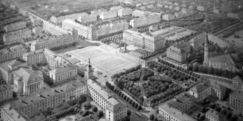
Even greater attention was devoted to the design of Soviet Square (Tarybų aikštė) itself, to be located on the site formerly known as Lukiškių Square. The project’s importance was evidenced by the organizing of the first invitation-only urban planning competition by the USSR Council of Ministers in Lithuania. Two designs each were to be submitted to the competition from architectural teams in Moscow, Leningrad, and Lithuania. The square’s central elements were to be the Victory Monument and the Government Palace complex. The overall approach was heavily influenced by newly constructed high-rise buildings in Moscow that became models for mandatory urban accent pieces in each republican capital. A more comprehensive design competition for the future Government Palace on Soviet Square was held in 1951, which selected for further development a proposal by V. Afanasyev, L. Kazarinsky, and A. Kolosov based on a Moscow skyscraper design. „Sostinės statybos (pasikalbėjimas su V. Mikučianiu)“, Švyturys, 1952, Nr. 13, p. 10–11. None of these projects, however, were ever implemented.
 
Transforming Lithuania’s Cities
 
A master plan document known as the “general plan” became the most important guiding element in the urban planning of socialist cities. As soon as 1950, such general plans had already been completed for Panevėžys, Telšiai, and Zarasai, and were in the final approval stages for Kaunas, Klaipėda, and Šiauliai. All of these urban reconstruction plans had common features, including a symmetrical, clearly defined city center surrounded by new residential districts, networks of expanded and straightened streets, a central boulevard serving as the city’s focal point, and the separation of industrial zones away from the urban core. Though the urban centers and architectural complexes of other cities in Soviet Lithuania received less attention than the capital Vilnius, they also underwent reconstruction of their central squares, the introduction of avenues and parks, the unveiling of obligatory monuments commemorating the Soviet Union’s triumph in the Second World War, and the construction of new administrative buildings based on standardized Soviet designs: regional Communist Party committee headquarters (raykom), regional executive committee buildings (rayispolkom), district Communist Party headquarters (obkom), district executive committee buildings (obispolkom), community councils, and collective farm administrative centers.
 
In Lithuania, the city that saw the most consistent implementation of such redesign plans was Šiauliai. A new central city square was already under construction there in 1945, based on a design for a uniformly laid out Victory Square with an 18-meter high Victory Monument, completed in 1947. The square was ringed by new construction projects: the so-called Palace of Soviets, the Communist Party District Committee Building (later occupied by the technical college)—adorned with columns, a frieze of oak leaf patterns, and the coat of arms of the Lithuanian SSR, as well as a four-story apartment building, the city’s executive committee headquarters, and a small plaza. Though not all of the ambitious reconstruction plans were implemented due to shortages in labor, construction materials, finances and other post-war concerns, the architectural designs of this period nevertheless left a distinctive mark on Šiauliai’s overall cityscape.
 
The new center of Lithuania’s port city Klaipėda, along Lenin (now Rebirth) Square on the right bank of the Danė River, was also meant to feature a new Palace of the Soviets, but construction plans were never implemented. Albertas Cibas, „Klaipėdos miesto rekonstrukcija“, Tiesa, 1946 06 21, p. 3. The old city square in Panevėžys was reconstructed and renamed Lenin Square (known as Freedom Square since independence). The center of the city of Marijampolė (renamed Kapsukas in 1955 in honor of a prominent Lithuanian communist leader), coalesced around the historical Jonas Basanavičius Square, renamed in 1952 to honor Karolis Požėla, one of the founders of the Lithuanian Communist Party. Arolfas Medonis, Po Sūduvą, Vilnius: Valstybinė politinės ir mokslinės literatūros leidykla, 1962, p. 17. 
 
The impact of the new urban planning principles was more pronounced in smaller cities and towns, where the reconstruction of historic urban centers proceeded without much regard for the pre-existing layout of the city or local architectural traditions. In the post-war years, monumental, oversized architecture forced itself into nearly every administrative urban center, such as Varniai, Salantai and Šakiai, and into many smaller towns throughout Lithuania.
 
Intensive industrial expansion and the opening of new military bases stimulated the development of Lithuania’s larger cities as well as the founding of new settlements around industrial plants, such as those near the Kaunas hydroelectric power station in Petrašiūnai or the Linksmakalnis military base. In 1948, Lithuanian architects drafted the first designs for post-war industrial settlements: Karpėnai (now Naujoji Akmenė, to serve a cement factory, designed by architect K. Šešelgis in 1953), and Grigiškės (near a paper processing factor, designed by P. Janulis in 1948). Local architects had few opportunities to deviate from standardized design plans for such settlements. The size of these industrial towns was calculated according to the number of personnel working at the associated facility, and all planning was to adhere to a symmetrical composition, with standardized buildings grouped along perpendicularly intersecting streets. Town blocks were to be built out with “homesteads” (singe-family dwellings for more highly qualified workers) along the block’s perimeter, or halfway around a block’s perimeter with multistory apartment buildings (with 4, 6, 8 or 12 units each) for factory workers. A new feature, unique to Soviet industrial cities, was the incorporation of a main street leading to a square and the settlement’s central building, the Cultural Hall—a manifestation of the Soviet ideological mission to provide “cultural recreation for the working people”.
 
The Impact of Socialist Urbanization
 
The impact of socialist urbanization is yet another subject whose traces are still visible in many historic Lithuanian cities, particularly in the Vilnius Old Town. Although the Lithuanian capital’s cultural significance was officially recognized by the state (Vilnius was added to a list of 20 historic Soviet cities in 1947 upon the recommendation of the USSR Architectural Affairs Committee in Moscow), Soviet urbanization principles gave priority to the modernization of the Old Town. “The Old Town, as the central and more densely populated part of the city, requires serious, immediate, and radical reconstruction,” read the report by a team of urban reconstruction specialists dispatched to Soviet-occupied Lithuania as early as 1941. This principle was known as “rehabilitation”, or the renewal of a city’s historic quarter. Stalinist cultural preservation, therefore, leaned toward protecting a city’s historic structure and buildings without impeding the convenience of a modern way of life. Under the guise of removing rubble left from the war, the opportunity arose to broaden Old Town streets, reduce the density of existing buildings, demolish entire neighborhoods and in their place lay down wide avenues, plazas, and introduce urban landscaping.
 
Complying with a 1948 directive issued by the USSR Council of Ministers, a Research and Restoration Workshop was established in Vilnius in 1950, though because of limited actual practical knowledge, most educational advancement came from studying local experience and mistakes. As work proceeded in the Old Town, the most critical problem became the issue of properly combining the use of historical and new materials. During the first post-war decade, however, architectural conservationists were charged with renovating only a few individual historic buildings, whereas the future of a more comprehensive approach to protecting historic urban areas remained unclear. In the first post-war years, the design and management of historic districts was assigned to urban planners, whose main task was the cleanup of war damage and the modernization of old towns. In Vilnius, for example, transportation needs presented a particularly large number of problems. As a result, many corner buildings were demolished or reduced in size, streets were broadened, and entire city blocks were “cleansed”. A new Rūdninkų Square, for example, was laid out on one entire block of demolished buildings that actually had survived the war fairly intact. The construction of a plaza along Pilies, Švarco and Gaono Streets required the demolishment of nearly one entire old town block, much like nearly all of the buildings on the north side of Vokiečių Street, the site designated as the future thoroughfare meant to bisect the entire Old Town.
 
The most pronounced modernization project in the Vilnius Old Town, the wide boulevard lined by multistory residential buildings along Muziejaus (now Vokiečių) Street, fully conformed to the principles of socialist urban planning prevailing at the time. In this one example, reconstruction work in the Vilnius Old Town was comparable to post-war renewal projects underway in Minsk and Kiev, where historic streets were being broadened and straightened (for example Kreshchatyk Boulevard in Kiev), and multistory buildings were constructed along the perimeter of newly arranged neighborhoods, with formerly isolated and closed courtyards being joined into extended and open common areas. In the end, however, criticism from local architects prevented the expansion of the avenue into the planned highway. The criticism eventually led to a “Vilnius Old Town Urban Conservation master plan”, organized by the Lithuanian SSR Construction and Architectural Affairs Committee. Drafting of the plan began in 1956 (with two independent proposals being worked on by the Research and Restoration Workshop and “Lietprojektas”, the official state design institute), and when the final version (based on the RRW proposal) was approved in 1959, it became the standard for the preservation of urban architectural heritage in Lithuania.
 

Comments

Write a comment
No comments.

Sources and links

„Sostinės statybos (pasikalbėjimas su V. Mikučianiu)“
Švyturys, 1952, Nr. 13, p. 10–11
Albertas Cibas
„Klaipėdos miesto rekonstrukcija“
Tiesa, 1946 06 21
Arolfas Medonis
Po Sūduvą
Vilnius: Valstybinė politinės ir mokslinės literatūros leidykla, 1962, p. 17
Vladislovas Mikučianis
„Nauji Vilniaus bruožai“
Tiesa, 1948 04 01
Николай Баранов
Основы советского градостроительства
Loading…
[[item.title]]
[[item.description]] [[item.details]]
You have subscribed successfully.
Patikrinkite savo pašto dėžutę ir paspauskite nat gautos nuorods norėdami patvirtinti užsakymą.